Geelong (jhe-LONG)
Orientation
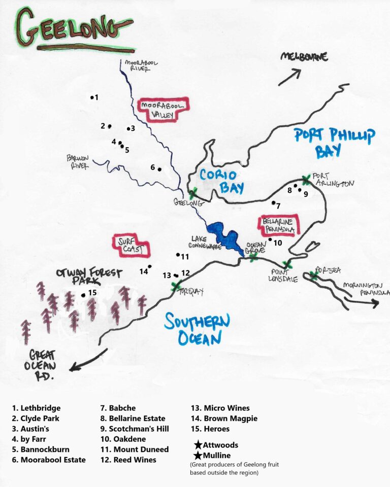
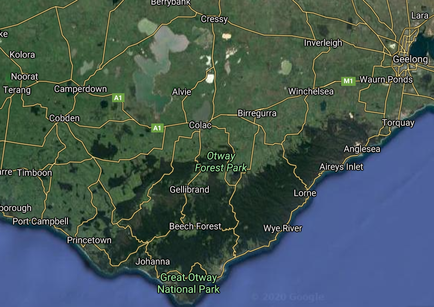
Victoria’s second largest city, and one of Australia’s oldest and most storied wine regions, Geelong is about an hour’s drive west out of Melbourne. The city sits on Corio Bay, an enclave in the western portion of the larger Port Phillip Bay created by the Bellarine Peninsula. The GI is one large swath of land, but the vineyard areas themselves are non-contiguous. Separated by large distances, the three distinct areas, or un-official subregions, encircle the city starting with the Moorabool Valley to the city’s northwest, the Surf Coast/Otways to the south, and the Bellarine Peninsula to the southeast.
The area is, as most of Australia, a patchwork of both ancient soils and recent formations. The oldest soils that can be found at the surface in the GI lie in the Moorabool Valley area. Much of the lower areas of western Victoria were once seabed. Years after the waters receded, volcanic activity added newer soils over top, and rivers spread alluvial sediments across the area. In the Moorabool Valley some of this seabed remains uncovered from volcanic activity, and has been eroded, spread and shifted by the everchanging path of the Moorabool River over time. When the rare limestone deposits and marly soils can’t be found, grey buckshot basalt soils, alluvial gravels, and mudstone dominate.
The Bellarine Peninsula is heavily influenced by watershed and has sandy gravels spread throughout, with some volcanic and clay based alluvial soils deposited by the water shed of both the Moorabool and Barwon rivers. Further south, the Surf Coast/Otways sit atop weathered basalt soils mixed with fertile volcanic loam that turns to sandy gravels as one nears the coast.
History
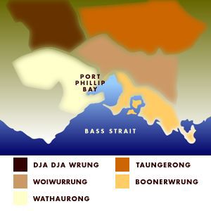
The greater area of Geelong was first known as the Wathaurong Nation. One of Australia’s more than 500 First Nations, the Wathaurong home extended from Lorne along the coast in the south, inland to the town of Colac, north to Ballarat and then towards the coast past the Lederderg Gorge. According to the Wathaurong Aboriginal Cooperative some 25 familial clans resided here totalling in nearly 300 people prior to European invasion, and was one of five nations that united to create the Kulin nation that encircled the what we call today Port Phillip Bay.
The city Geelong was “established” by Europeans between 1836 and 1838, about thirty years after the first nonindigenous person landed in the area of Port Phillip in early 1802. Subsequent surveyors arrived from Sydney in and around the area and while seeking to establish the Sullivan Penal Colony, the HMS Calcutta led by Lieutenant Colonel David Collins sent a party to what is now known as Corio Bay where the first death of a Kulin Nation person occurred at the hands of a European in Victoria.
The area was known by the Wathaurung people as Corayo, and the greater bay being called Djillong. Depending on which Wathaurung clan elder one speaks to, Djillong means “Land, Cliffs, Tongue of Land”, or “Peninsula Over the Sea”.
The next 15 years, the Wathaurong population declined from 300 to 30-40 due to the introduction of influenza, loss of food sources from the introduction of cattle and sheep, and murder. Over 140 archaeological sites have been discovered across the area known to be Wathaurung Country, speaking to the complexity and size of the First Nation. These 15 years also brought great prosper and growth for the colonial establishments in the area. Wool production, manufacturing, and one of the world’s largest gold rushes, centered in Ballarat along the Moorabool River, fuelled rapid growth.
While the Wathaurong Nation was under siege, the first commercial grape harvest occurred in 1845 from the Neuchatel Vineyard (planted in 1842), and by 1860 Geelong was the most significant wine region in Australia in both size and stature. The city and region were booming and wine exports back to Europe were common, with the equivalent of nearly 150,000 cases of Victorian wine exported to the UK annually through the mid-1870s. Geelong had grown to 550 acres of vines and accounted for over half of the entire Victorian vineyard surface.
In the beginning of the 1870s phylloxera was discovered in vineyards, and in response the government ordered the complete removal of every vineyard in the area to prevent further spread. Some believe that local officials held financial interests in competing regions like Rutherglen, and the drastic response was not solely motivated by the will to stop the louse from spreading further. By 1883, the industry in Geelong had come to a screeching halt, and not a single vine remained.
In 1892 the region was permitted to begin planting vineyard land that had laid fallow for 10 years. However, a massive economic depression in 1893 prevented the wine industry from re-establishing itself. It wasn’t until the 1960’s that the region started to replant, with the Idyll being the first in 1966 at the hands of Darryl and Nini Sefton.
Today, the greater Geelong region ranges from a dense city of 250,000 residents, rolling grasslands full of grazing sheep, a breathtaking coastline home to the start of the Great Ocean Road, beachside estates, and vineyards and wineries of all shapes and sizes.
The Moorabool Valley
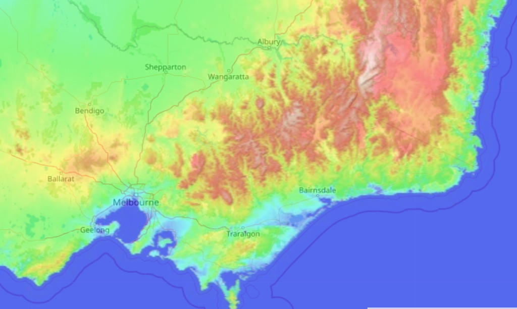
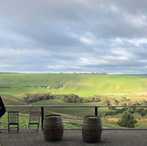
Defined by the path of the Moorabool River, this valley is a gently undulating verdant oasis surrounded by typically sunburnt dry grass lands. The river originates in the western ends of the Great Dividing Range. The bulk of these mountains runs north to south parallel to the east coast, and turns west in central Victoria. The ranges begin to peter out north of Melbourne, and the last outcroppings are the gentle rises in Ledederg (640m), Wombat Forest (820m) near Ballarat, and finally the Grampians (1100m) which mark the official end of the chain.
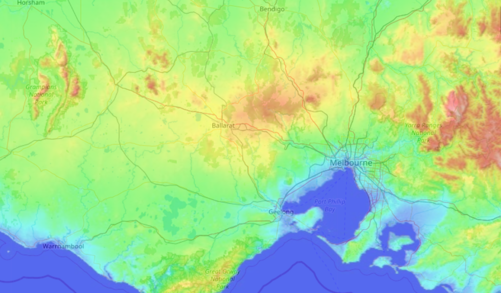
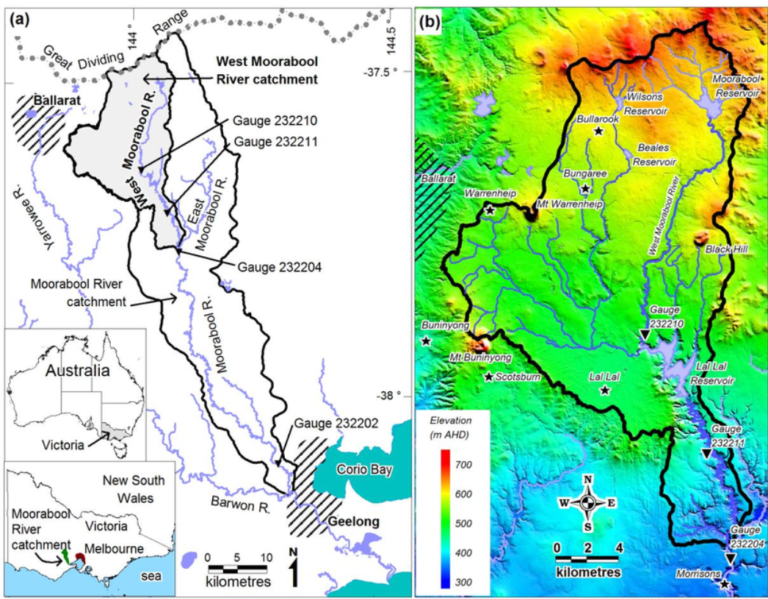
The meandering path of the Moorabool River created a valley with highly favorable north eastern exposures on gentle slopes. The river valley acts as a wind tunnel quite similarly to that of the Napa Valley. However, it’s not usually cool, Antarctic air that is drawn north from off of the bay, but hot dry winds that rip down the valley and create viticultural challenges that can impact flowering and keep precipitation to a minimum during the growing season. Usually, the hot dry front from the north pushes the moisture band further south out over the bay (except for in cooler months). This is why it rains in Geelong in the winter and not the summer, and why the growing season is unusually quite dry.
While the river provides moisture for the lowest-lying farmland in the area, the lack of precipitation prevents growers from dry farming. There has been no shortage of experimentation, but it often results in an imbalanced vineyard with vines under so much water stress that you can literally taste it. Most precipitation comes in the winter giving growers the opportunity to collect their irrigation supply in dams from runoff and rain, though these days you’re lucky to see a full dam at bud break more than once every 5 years.
The Moorabool is the original home of Geelong viticulture, and is where the 1960s reestablishment began. Shortly after Idyll Vineyard was planted, vineyards continued to be established. In the early 70s, Bannockburn was founded by Stuart Hooper in its eponymous locale. With Gary Farr at the helm, Bannockburn led the charge for Geelong to return to glory. Just a few kilometers north along the valley Clyde Park was built, and the Austin family set up shop on the other side. Amidst these wineries, vineyards were being planted by growers and winemakers alike. The by Farr property was slowly established by Gary towards the end of his tenure just next door to Bannockburn, and is run today by his son Nick. Lethbridge is another notable winery of this region, with proprietor and winemaker Ray Nadeson at the forefront of Australian ingenuity.
It is along this stretch of the Moorabool Valley, from Bannockburn through Lethbridge and Steiglitz and up to Meredith, where much of the exposed ancient sea bed can be found in vineyards thanks to both the eroding effects of the meandering river, and random areas uncovered by younger volcanic deposits of basalt.
In the Moorabool, pinot noir, shiraz, and chardonnay are the most notable plantings with everything from riesling to cabernet sauvignon finding a home on both alkaline limestone and acidic basalt soils. However, the climate is still moderate enough where in some difficult cooler vintages late-ripening varieties like cabernet sauvignon fail to fully ripen.
The Bellarine Peninsula
Southeast of the city of Geelong, the peninsula forms the western barrier of the Port Phillip Bay and the smaller Corio Bay on its northern shores. The peninsula’s climate is practically opposite that of the Moorabool, and certainly warrants the official establishment of separate subregional GIs. The cooler coastal climate chilled by Antarctic winds fosters a heavier focus on white grapes like sauvignon blanc, chardonnay, and pinot gris. Successful sparkling efforts along with a small amount of pinot noir and a few lighter expressions of shiraz and cabernets can be found too.
The two most notable producers on the peninsula are Oakdene and Scotchman’s Hill, with Scotchman’s being the first established in 1982. It should be noted though, that while these wines all note their home as the Bellarine Peninsula, their GI classification is from the broader Geelong appellation. The peninsula, unlike the Moorabool Valley, is a picturesque peninsula home to both bayside and seaside estates, tourist destinations, bustling cellar doors, restaurants, and vineyard-set wedding venues. One to watch in this area is the newly founded Babche, focusing on pinot noir, chardonnay, and sparkling wine made with zero additives, and zero weddings.
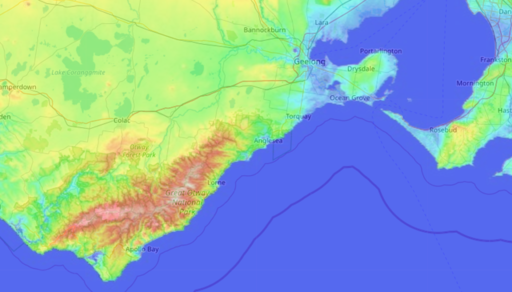
The Surf Coast/Otways
While the names are used interchangeably, the Surf Coast and the Otways describe two distinct areas and influences. The Otways Ranges are a lower altitude mountain formation (peaks at around 650m) that run parallel to the coast extending southwest from Geelong.
100 million years ago, the Otway coastline was a part of the Antarctic circle. Fast forward – a lot – and the area was home to the Gudabanud people of the Gudabanud Nation. This First Nation was the southern neighbor to the Wathaurong Nation mentioned earlier, and not a part of the greater Kulin Nation. The Gudabanud people were not subject to European invasion as early as their neighbors to the north.
8,000 years ago, around the area of Colac (a town just north of the modern-day Otway Forest Park), a volcanic complex created what is now the world’s third largest volcanic plain. The large lakes to the north, the fertile farmland extending south and east, and the lush, waterfall-studded Otway Forest full of California Redwoods, all came to be after this volcanic event.
Cape Otway remains a traditional land of the Gudabanud Nation, and descendants continue their heritage today.
The Otway Forest extends north to define the southernmost vineyard area in the appellation. Vineyard areas extend to the northeast parallel to the coastline, between 10-20 km inland from the sea or further inland in what is known as the Otway Hinterland. As a whole, the region is heavily influenced by its proximity to the coast. The Otways National Park and Forest boasts some of the highest average rainfalls in the state. Warm fronts from the north push the moisture band south from time to time, but the vineyard areas here get a healthy amount of rainfall year in the cooler months that makes dry farming possible.
Waurun Ponds marks the northern limits, and the original plantings of the Surf Coast/Otways area. Estates like Mount Duneed or Brown Magpie are large operations boasting big cellar door restaurants and party venues that are quick drives to the coast, while modest and earnest producers like Heroes sits quietly in the hinterland, meticulously farmed, sitting next to a winemaking facility all about function. Smaller still, producers like Sierra Reed and Micro Wines share winemaking space in the town of Torquay, and source fruit from single, more prized sites from within the Moorabool Valley and beyond Geelong. A variety of grapes are grown, veering toward those that suit cooler climates: pinot noir, chardonnay, riesling, and pinot gris all do quite well, with later ripening varieties like Semillon excelling in warmer vintages.
The Surf Coast, and its beachside towns of Torquay, Lorne, Bells Beach, and Apollo Bay is an international tourist destination. A few wineries stud the coastline, but they are not surrounded by vineyards. The Surf Coast might describe the locale, but the greater vineyard area is just as defined by the forested volcanic plain that is the Otways as it is influenced by the coast.
Summing Up
Geelong’s story is one worth reading the longer version. From Melbourne, it is the gateway into the wild western Victoria. And its natural wonder is as incomprehensible as its troubling history of destructing the traditional custodians of Australia.
As for the wine, Geelong went from being one of the most esteemed and productive regions of the 19th century, to an underdog in present day. Of the 136 wines on the 7th Edition of Langton’s Classification, only two of them are from Geelong (and both produced by the same winery – by Farr). Like many appellations across the world, its boundaries are more geographic than anything else, and the subregions of Moorabool Valley, Surfcoast/Otways, and Bellarine Peninsula carry a lot of weight and distinction. This is a region that continues to grow and impress, with new wineries from inside and outside its boundaries interested in the quality and diversity of fruit grown.
The Future of Geelong as Seen Through the Wine Australia Climate Atlas
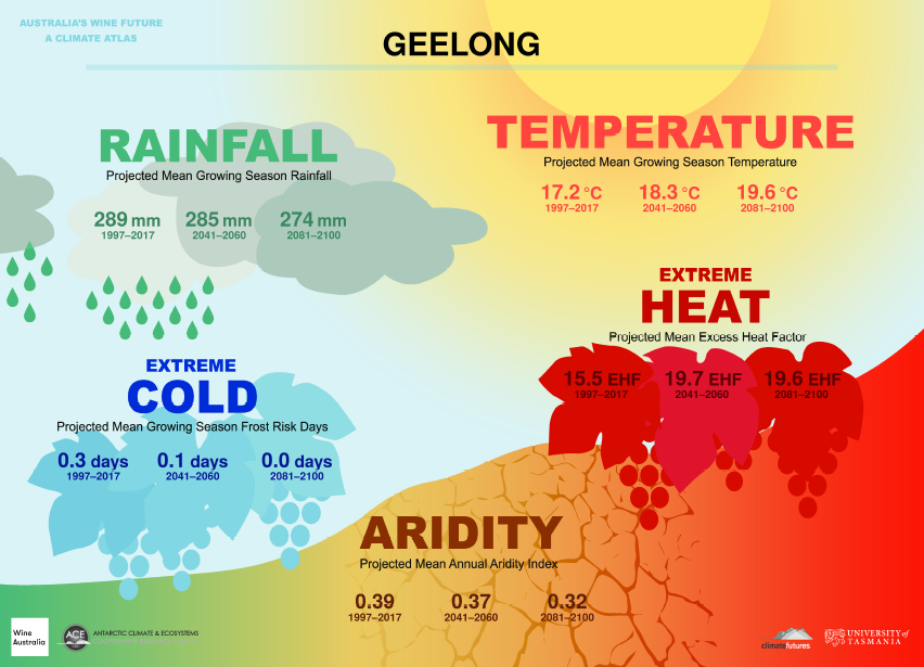
The Climate Atlas is the culmination of a three-year study lead by the University of Tasmania, and analyzed 70 years of historical data across every Australian GI. Their predictions are based on this history, and present crucial metrics to understand what the next 80 years of climate change will bring to Australian viticulture and greater human life.
Notes and Definitions
- Growing Season is defined as the 6 month period from October 1st through April 30th, and is the time frame referenced by the Rainfall, Temperature, and Extreme Cold indexes.
- The Aridity Index uses an annual picture rather than the specific growing season within the year. It indicates the availability of water by measuring the accumulation of water against the evaporation of water, and represents the difference between the two. It does not take into account soil types, shading, changes in farming practices, or vine schematics (material, planting density, irrigation), but does take into account slope, aspect, elevation, humidity, and the effects of wind patters. There are few places in the world where rainfall is expected to increase at an equal to or higher rate than the increase in the rate of evaporation, so the entirety of Australia is expected to become increasingly more arid along with most of the world’s wine regions.
- Heat analysis and projections come with a high level of confidence across the climate analysis industry. Projections are linked to emissions models, and span a variety of well understood variables.
- The Extreme Heat Factor is used to measure the effects short-term intense heat experienced during heat waves have on humans. This factor is based on the three-day time period definition of a heat wave as it relates to the preceding 30-day temperatures of a specific place. Heat waves are large scale events that do not depend on specific regional details, and therefore the data relies more on overall climate change.